Friday, August 26, 2016

Custer and Discuster


July 8-9

We reached the Days Inn in Custer, S.D., around four on July 9, after spending much of the afternoon marveling at the big game in Custer State Park. We passed signs for Custer Gulch, Custer Mountain, and Custer Whatever.

He was a celebrity in his day. But I believe that, if he hadn’t been arrogant enough to attack the entire Sioux and Cheyenne nations with half a regiment of cavalry, we might not even remember his name today. 

On the eighth, we prowled the Prairie northeast of Wall. The road passes a huge Wall Drug billboard accompanied by a green dinosaur facing east on a bluff over interstate 90.


Then you dive into that rolling sea of grass. We entered the town of Philip. With a populaton of 858, it is bigger than Wall by 40 souls.


There is a small park with a log cabin that was a schoolhouse at the end of the 19th century. It has been placed next to the clapboard one-room school house that was the town’s original school.


We went back to the Badlands; it’s hard to keep away. We rephotographed the south wall. We also revisited the section called the Yellow Mounds. The yellow resulted from the burial of an ancient jungle. The jungle came back, was buried by more deposits, and this time turned the earth red. 


We went to the Red Rock Restaurant in Wall for dinner. Even with all the farms around us, this is processed-food country. I think the clam chowder was not made from scratch in the kitchen. Ditto the breaded wall-eye filet. Not bad, though, for a change from buffalo and beef. 

The bar serves Barefoot wines. I tried the chardonnay and pinot grigio. They were light, and I think the chardonnay had more flavor than the pinot grigio. I had a cabernet sauvignon, too, and it was fine.

Of course, I have almost never tried a wine that I didn’t like.

We went to Wall Drug for pie.


Then we set out to see the sun set over the Badlands. The shadows put many of the formations into high relief. The Yellow Mounds are gold and red. Buffalo are said to be active at dusk, but we didn’t see any.


Custer State Park, on the ninth, was a different story.

You enter from the east side on U.S. 16A. You pay $20 for a ticket that’s good for a week, so we’ll probably be going back there once or twice over the next few days.

The park is in the Black Hills, not far from where Custer’s expedition of 1874 found gold. The Black Hills were ceded to the Sioux by treaty, but the gold rush was on. The cavalry sent the first trespassers home, but when the big rush came, gave up. Or didn’t care. Anyhow, it was the end of yet another treaty between the United States and an Indian nation.

The Black Hills are covered with dark evergreens. I understand that is the origin of the name. 


The animals in the park are apparently enured to traffic. A group of young pronghorn rams drew quite a crowd of cars and motorcycles. They were right by the side of the Wildlife Loop Road, and were perfectly undisturbed by the uninvited company.


We saw a cluster of wild ponies grazing in the distance, and a couple of herds of buffalo. We needed to use the binoculars to see them clearly.

A solitary bull buffalo was lying on the grass maybe 50 feet from the road.

Later we saw cars going up a side dirt road called Four Mile Draw. This was yet another herd, maybe a hundred or so, bulls, cows, and calves. They came right up to the edge of the road. Cars were lined up and arms were sticking out of them with cameras and cellphones.

Ignoring the advice at the visitor center, I got out of the car. Those animals couldn’t have cared less about me. They didn’t even look my way. I can’t blame them. They were hungry, and besides, all one would have to do is step on me if I got out of line.

I got lost for a few minutes on the way out of the park. I had started out toward a few features in the far north end. These are narrow tunnels, and something called the Needles Eye. Joanna looked at the park map and said, “That’s near Crazy Horse.” We’re going there later so I decided to save it for another day. 

I told Joanna that I’d turn around and head for Custer. She thought we didn’t have to turn around. But we’re on 87 North, I told her, and pointed to the map.

She pointed out some landmarks that we had just passed. She was absolutely right, and I was so damned sure I knew where we were. 

The first gold prospectors were a family named Gordon. They entered the Black Hills illegally and after a year were driven out by the U.S. Cavalry. They had built a stockade near what is now the western entrance to Custer State Park.

There is a reproduction of it just outside the park by the highway. It was raining, so we didn’t stop. 

Custer is bigger than Wall. It has more than three restaurants and even has a car wash.

Joanna and I are headed out for dinner soon. The man at the desk told us we had to eat dinner early, because the town closes up by 9:30.

But that’s all right. After a day on the road, so do I.

Be well, all.

Harry


Thursday, August 25, 2016

Buffalo Hunt


July 6

We enjoyed the burgers so much at the Badlands Saloon that we went looking for more buffalo today. And we found some, too, but couldn’t get within range.

I picked up my prescription at Wall Drug. But we had breakfast there in the Wall Drug Cafe. Billboards all the way to the state line advertise what Wall Drug has to offer, including home-made donuts and 5-cent coffee. So in addition to eggs and bacon, that’s what I had. Joanna had some very good pancakes.


After breakfast, we walked around and looked at some of the attractions. I bought a cheap switchblade and a conventional folding knife in the camping goods department. Joanna bought a travel pillow and some myrrh-scented balls.

We saw the replica mine, walls and walls of historic photographs, the jackelope, and even an animatronic T-Rex.


We also stopped at the Buffalo Gap National Grasslands visitor center, which is a block up from the drug store in the two blocks that constitute downtown Wall. According to a ranger, most of the bison are in the Badlands National Park. The national grassland wraps around the park, and there are some buffalo in the section south of the park.

So we headed in that direction. We went back to the park, entering this time at the gate where we left the day before. This time we took a gravel road, Sage Creek Road, through part of the park we skipped yesterday.

There is a section labeled Roberts Prairie Dog Town. That is apparently a misnomer for Prairie Dog Metropolis. It stretches for miles along both sides of the road. There is an overlook where I was able to get out and walk on a couple of short tracks throught the town. The prairie dogs sat at the doors of their burrows and squeaked in protest.  

Farther along the road, we saw some dark spots on the prairie. Even with the binoculars we couldn’t be sure what we were looking at. One silhouette looked like the mismatched halves that make up a bison—the huge head and hump and the relatively small ass end.

Another mile or so, there were cars parked on both sides of the road. That’s an indicator that somebody has seen something. This was a smaller herd, but much closer. Even without the binocs, I could make out the shapes of buffalo bulls. With the binoculars, I could see the calves following the cows.

Curiouser and curiouser, though, were a small herd of almost tame bighorns. They were ewes with young, four adults and four lambs.


They were on a bluff below a viewing area, and just walked by us all, and passed between two parked cars, one of which had its engine running. All, that is, save one ewe and the lambs. The ewe waited for the running car to leave and then joined the other adults, which were grazing at the roadside. 

The lambs went a few yards back down the hillside and started grazing there. They had the same attitude toward humans as that monkey in the Cambodian temple. 

It ate fruit from a bag and ignored the Chinese tourists who posed for photos that would look like they were petting it. 

Ignored them, that is, until one came too close to the bag. that brought a quick hiss and a show of teeth.

Nobody pretended to pet the sheep.

We continued on the gravel road till we left the park and eventually came to South Dakota Highway 44. This is one of the roads we traveled through Hutchinson County a couple of days ago. This time it  took us through the Badlands and across the Grasslands, with nary a buffalo in sight.

We did see some workers on the roadside who appeared to be out to kill prairie dogs. Now, given my experience with something as small as chipmunks, which were able to undermine my driveway a few years ago, I can understand that.
But then we took a gravel road north back to the Badlands National Park. Shortly after we turned onto it, we saw a sign: "Prairie Dogs Have Plague." It advised us to keep our pets in the car.
We also ran into a traffic jam of sorts. Nobody honked any horns. They just mooed. Unfenced cattle had decided it was time to cross the road. 


They must do that a lot, judging by the evidence. There was cow shit lying in the middle of the road for the next mile or two.

The wall of the Badlands is very clear when you see it from the south. It really is a barrier. It reminded Joanna of the Great Wall, which she visited a few years ago on a trip to Red China.


The trip back to Wall took us through the striking section of the park with the gold and red mounds. 


We rested at the motel for a while and then went out to dinner. We tried a new place, the Cactus Cafe. It took me three tries to order a beer. The waiter kept disappearing before I could ask for anythng. When I finally asked for a New Belgium, which was on the menu, the waiter looked at me and said, “I have to ask.”

I asked him to explain. I have to ask to see if we have it. Well, yeah. 

He seemed surprised that it was his job to find out. He went and came back and said they had three ales. One I didn’t know. I asked him about it. “I don’t know,” he said. We said good-bye.

We had salad, mashed potatoes, and a rib eye at the Badlands Saloon, where we had the buffalo burgers yesterday. We tried some chicken gizzards, too, as an appetizer, but it was like trying to chew leather. We gave up on them.

I had a New Belgium Fat Tire, an amber ale that I have had a few times before; the Deschutes Fresh Squeezed, the IPA I had yesterday, and something new to me, Moose Drool, a brown ale from Big Sky Brewing in Missoula, Mont.

Joanna asked the waitress about a supermarket. There’s one up the street from the bar. In fact, it’s just around the corner from our motel. So we walked there to buy some fruit and a few other supplies.

We tried to get some pie (also advertised on billboards) at the Wall Drug Cafe, but it was almost nine and the place was shutting down. I keep forgetting that 9 p.m. is late in much of the United States.

So that’s another day in former Sioux country, gang.

Be well, all, and to all a good night.

Harry


Wednesday, August 24, 2016

Hitting the Wall


July 6

We found out today what Wall is named for. It isn’t the drug store, although you might expect so. All the way from Sioux Falls there are billboards every half mile or so making promises about Wall Drug—homemade donuts, 5-cent coffee, ice water, cowboy gear, old time photo ops, buffalo burgers. 

I believe there is an actual pharmacy there, too, so I’ll see if they can refill a prescription for me tomorrow.

Right now, I am confined to quarters by a tornado warning for this section of South Dakota.

We made it to Wall from Kadoka by taking a detour through the Badlands National Park.

We stopped at a scenic overlook on Interstate 90. It must have been 50 or 60 feet above the road, making it the highest point in sight. The similarity of the prairie and the open ocean is striking. The land isn’t perfectly flat; there is a gentle roll that repeats like waves in a light wind. 


And there is always a wind here in the summer. They call it 
a monsoon.

At I-90 exit 130, our route took a southerly course (never mind that the road is S.D. 240 West) toward the Badlands National Park.

Just before we got there, we had to stop, though, to see something that surprised me. There is a preserved homestead with the original sod house a short distance from the national park entrance.


It was built in 1909. I had read about sodbusters in sod houses, but thought they had all switched to wood or bricks by 1900. Not so. They were just getting started. 


The sod house at the Prairie Homestead Historic Site was built by Ed Brown and his wife, Alice, who registered for a tract of land under the Homestead Act. They came West from Nebraska in a Conestoga wagon. Ed lived at the farm till he died in 1920. Alice left in 1934 to live with a daughter. Others moved in after them. The place was occupied until 1949.


A granddaughter later restored the farm and turned it into the historic site, which is still privately owned.

The structure is made of improvised bricks, actually blocks of sod cut out of the ground. The roots of the prairie grass hold the soil together. The blocks are stacked to make very thick walls, which we were told are good insulation against the summer heat and the winter cold.

The inside walls are partly covered with boards. The upper half remains exposed sod, which is in surprisingly good shape.


The family added a small, one-room wood cabin that they bought and brought from another site.  

The residents now are chickens and goats with names like Chocolate and Billy the Kid.

The Badlands were once a seabed, then a jungle, and later a river valley covered with sediment and ash from distant volcanoes.

The result is intricately eroded soft rock formations that look like clay. You can see stripes on the cliffs marking the different geological layers.

The edge of the Badlands forms a wall the people used to have to cross carefully, if at all. The wind erodes it an inch or more a year, so it’s always moving. We passed one point on the park road where the edge has crept to a matter of feet from the pavement.


Today there are people climbing all over the rocks. It’s fun to stand on some of the prominent formations, but my sense of balance has always been questionable, so I have a hard time relaxing on narrow trails in high places.

I stayed mainly on the boardwalks. 

It was amazing. There were sections that looked like the weathered temples of Angkor Wat. Others looked like bizarre castles.


We got out of the car at almost every overlook. We got stuck in a traffic jam, which turned out to be a rubbernecking delay caused by bighorn sheep grazing at the side of the road. We saw a pronghorn lazing on a hilltop. Another, or maybe a deer, was grazing on a grassy slope. 


We made it to Wall around 3 or 4 o’clock. We were about to go to Wall Drug to refill the prescription when an alarm sounded. It lasted a long time. I asked about it, and the people in the office said it was a tornado alert. 

We were supposed to stay indoors, so that postponed drug store and dinner, too.

TV reports explained that there were severe thunderstorms, some with winds up to 60 mph and huge hailstones, to the north of Wall. No tornadoes had been reported, but conditions made them a possibility.

We got hit with heavy rain, and then it cleared. We went to the Badlands Saloon and Grille for buffalo burgers and a couple of beers—IPAs from Deschutes in Oregon and from Crow Creek Brewing in the Black Hills.

Then we went to Wall Drug. We were tired, so we didn’t explore the place, which is like a self-contained mall. The pharmacy was closed by the time we got there, so I’ll go again tomorrow.

I’m eager to have a pill bottle with Wall Drug’s name on it.

In short, no tornado, no hail, exotic animals, fanciful rocks, and primitive architecture. So far, so good.

Love to all.


Harry


Tuesday, August 23, 2016

Sioux Me


July 4-5

It’s a long haul from Baraboo to Sioux Falls, but I can’t complain. John Dillinger made the trip all the way from Chicago 80 years ago before there was an Eisenhower Interstate Highway System. He came to rob a bank.

I came because it is a way point on the trip to the Badlands.

The route we took, Interstate 90, has a section of hilly country, but most of it is prairie. Crossing South Dakota is like sailing on the ocean: you can almost see the curve of the Earth.


We left Baraboo a little after noon. We had gone back to the Ishnala to see if we could improve our snapshots. We also stopped at a Starbucks store to use the wifi because the system was down at the Clarion. I needed to consult Google Maps to confirm the last part of the drive to the Dakotah Lodge at Sioux Falls.


We crossed the Mississippi. Even this far north, it’s so big, I thought at first it was a lake.

Does anybody remember Sinclair and its green dinosaur? They still have that brand of gasoline out here.


One of the rest stops had an interesting juxtaposition. An old marker from decades ago talked about the significance of “vee-shaped ditches” along roads and between fields. They allow the prairie land to drain so it can be cleared for agriculture. Millions of acres have been affected, contributing to the prosperity of South Dakota.

Facing that, a few steps away is a newer sign talking about efforts to conserve the prairie, which has been all but wiped out of South Dakota. Efforts are under way to restore some of it. Vegetation of the natural prairie consists of tall grasses, some of which can grow six feet high. The roots of many native prairie plants reach as much as 15 feet into the ground. This helps them weather drought. The dense cover and deep roots make it hard for invasive species to compete.

We got into Sioux Falls a little after six on the Fourth. We asked about places to eat and got directions to Phillips Street. 

The neighborhood is a gentrification. It reminded me of Asheville, or downtown Fredericksburg with wider streets—1920s storefronts made hip.

Minerva’s, the place specifically recommended, was closed for the holiday. So were a couple of other restaurants, so we wound up at a bar that had 40 taps but served only hamburgers.

Very good, though, especially with the freshly cooked potato chips. I had a Founders nitro stout (the nitro makes it smooth and creamy, like Guinness) and a very fragrant Sierra Nevada Five Hop.

Joanna has been following our progress on state maps that we pick up at welcome centers. She noticed there is a Hutchinson County in South Dakota, not far from Sioux Falls. So we went there to wave to my relatives.

It’s a wide-open rural space. Huge fields of corn and other crops surround small clusters of buildings—usually a big house, an even bigger barn, and some smaller structures.

By coincidence, Interstate 90 brought us to the neighborhood of the Corn Palace.

It’s in Mitchell, S.D., just north of I-90. I always pictured it as standing by itself on the prairie and surrounded by tall grass. But no, it’s in what they call Historic Downtown and appears to be attached to City Hall. One of the current murals outside is a portrait of Willie Nelson rendered in shucked ears of corn.

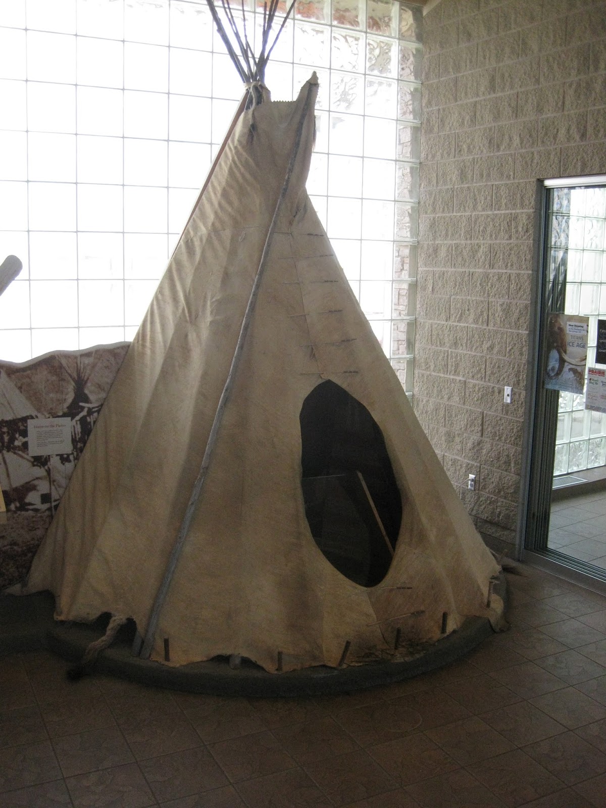
We stopped later at a rest area dedicated to Lewis and Clark. A replica teepee stood inside the visitor center and we got a great view of the Missouri River behind the building. Like all the South Dakota rest stops, it is identified by an oversize concrete teepee on the grounds.


There was a sign telling me to be aware of poisonous snakes, so I went down the path looking for some. No luck, though.

A second floor of the visitor center was set up like the keelboat that the Corps of Discovery used much of the way up the Missouri. The river eventually became too shallow for the boat to navigate, so it was loaded with specimens collected on the way and returned with a small crew to St. Louis, where the expedition had started.

When we came out, there was a strange vehicle being carried on a trailer. I didn’t know if it was a thrust car or a catamaran. It was clearly a racing vehicle—very wide and very flat. It had a small cockpit and a gas turbine.


It was mounted on a special carrier that held it at a 45 degree angle because it was too wide to ride flat on the highway.

We spoke to the lady who owns it. It’s an aquaplane, a boat with wings. It doesn’t use the thrust of the engine, but instead uses the engine to turn a propeller, which had been removed for transport.

The boat had been in a race somewhere far to the south (she said, but I forget where) and was going home to Seattle, where it would run in a couple of other races.

We got to Kadoka, near the Badlands National Park, around 5:30. We picked up an hour because we crossed into the Mountain Time Zone.

I was beat and took a nap. Joanna brought her rice cooker and cooked a few ears of corn that we picked up at Wal-Mart, appropriately enough, not far from the Corn Palace.

My computer is telling me it’s 11:42 back in New Jersey. It’s almost ten here. I’m getting ready to pack it in, gang.

More later.

Harry


July 7

I remember Sinclair gas!

Amazing they're still around.

South Dakota sounds like a good place for an adventure.

Charlie

July 7

Now this is more like it, Grasshopper. Interesting and, I'm sure, beautiful.

Larry


Sunday, August 21, 2016

Crossing State Lines


July 1-3, 2016

I’m writing this on the morning of the Fourth at a Clarion in Baraboo, Wis.

We left New Jersey around 10:30 July 1 and made it to Hubbard, Ohio, not far from Youngstown, by dinnertime. July 2 we crossed Ohio and Indiana to Portage. Both days were largely spent driving. Stops were mostly at rest areas or gas stations.

Portage isn’t much fun. We wound up eating dinner at the Denny’s next to the motel. But we were only 20 minutes from Indiana Dunes State Park.

We went to the visitors’ center, which is outside the park itself. Next to the building, there is a garden designed to filter water on its way to Lake Michigan. 

The building is open 24 hours a day. There is a sign in the window that says “Safe Area.”

Turns out, there are at least two rooms in the structure that are labeled as tornado shelters. 

There is also a kiddie room with samples of dead animals.

One of the highlights had nothing to do with natural habitat or conservation. The Lakeshore Dunes, like the dunes at Kitty Hawk, provide elevation in the face of strong winds.

Octave Chanute, an engineer from Chicago, used the dunes as a laboratory to study glider flight. There is a replica of one of his gliders hanging from the ceiling of the center. He laid a lot of groundwork that he shared with the Wright brothers.


You can see how it is the forerunner of the Wright Flyer. Except that the Wrights’ plane had a three-part stabilizer, not four.

We went to the park, but forgot, though, that it was July 3. We sat in a line of traffic for almost 45 minutes to get in. The parking lot was jammed with tailgaters, so we had to be careful not to run over their children as we looked for a parking spot.


We saw Devil’s Slide, a dune maybe 70 feet high and covered in trees. There is a wide sand trail leading to the top.


Then we went to the Cowles Bog Trail. I’m very fond of bogs. This one is sheltered from Lake Michigan by a large hill. This may be a dune, too, but I’m not sure.

We walked for a half hour or so, listened to the frogs croak, and decided it was time to head for Baraboo.

We got the “low fuel” light somewhere before Chicago. When we paid the toll to continue on I-90, I asked about gasing the car. The toll-taker said there is a gas station three miles on. 


The sign was so small that I was on it and gone before I could read it. I wound up getting off the highway a couple of exits later. There was no west-bound re-entry.

Meanwhile, the computer lady in the Garmin GPS (who has an Australian accent, by the way) every block or two announced, “Recalculating.”  We stopped for gasoline and continued in the direction she had told us. Again “recalculating.”


She told me to take rights that didn’t seem to exist. Then she put us on a highway that took us back to I-90.

No problems after that. We wound up in Baraboo around 6 Central Time.

The lady at the desk told us about a supper club called Ishnala. I wondered if she was mispronouncing “inshallah,” Arabic for “God willing.” It’s something Moslems are supposed to say every time they talk about their plans. 

OK, I’m thinking, hummus, felafel. It could be fun.

No, though. It is Inshala, which, according to a sign in the bar, means “by itself alone” in Winnebago. 

Welcome to Wisconsin Dells, the equivalent of Disney World in the Upper Midwest. There were more dead animals in the restaurant, along with a dummy Indian identified as Chief Inshala. There were fake teepees outside and totem poles at the entrance to the road leading to the parking lot. 

The place was packed. The campgrounds were loaded with trailers and tents. There was an hour and a half wait for a table. We decided to stay.

We walked around the grounds and entered a trail in the neighboring nature refuge. I didn’t want to go too far because I didn’t know the range of the device they gave us. It is one of those radio boxes that light up, buzz, and vibrate when you’re table’s ready.

We went back to the bar. The bartender didn’t know what Campari was, so I had a dry vermouth and club soda. This is a very light highball. I actually used it one night in Atlanta years ago to sober up after taking too much craft beer at dinner.

Dinner was surprisingly good. I had snails to start and Joanna had an excellent French onion soup. We sampled each other’s appetizer.

We shared a dish called chicken Oscar, which was a lighly breaded boneless chicken breast covered with lump crab and a sauce of some kind.

Then it was time to call it a day.

I don’t know when I will send this because the wifi has crashed here. Or maybe it has been hacked. I’m not sure. All I know is that the system won’t let me in, and when I called the desk, the hotel had already sent a message to the company’s IT department.

Be well, all.


Harry


July 5

Wisconsin?

Perhaps a name for your next missive: Travel Tips for Masochists.

(Try to) have a good time.

Larry